
We are excited to announce the release of ESdat GeoChem for geochemical data, a game-changing addition to the ESdat environmental data management software suite. With the launch of ESdat GeoChem as part of Version 4.5, users can now experience unparalleled capabilities in visualizing and analyzing geochemical data, making informed decisions and streamlining their environmental projects like never before.
Key Features of ESdat GeoChem:
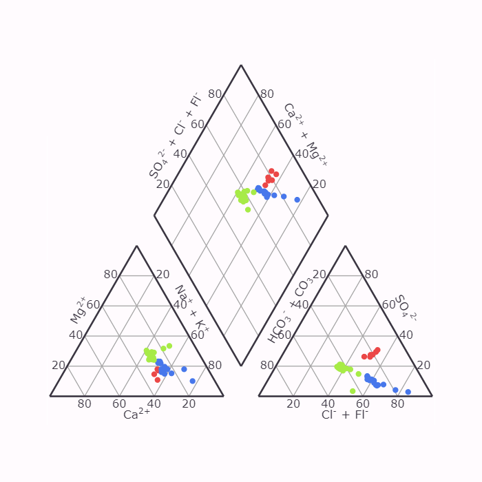
- Comprehensive Geochemical Data Visualization: ESdat GeoChem offers an all-encompassing solution for visualizing geochemical data in various formats, including the widely-used Piper, Schoeller, and Durov diagrams. These powerful visualization tools provide invaluable insights into milliequivalents per litre, enabling users to grasp complex data effortlessly.
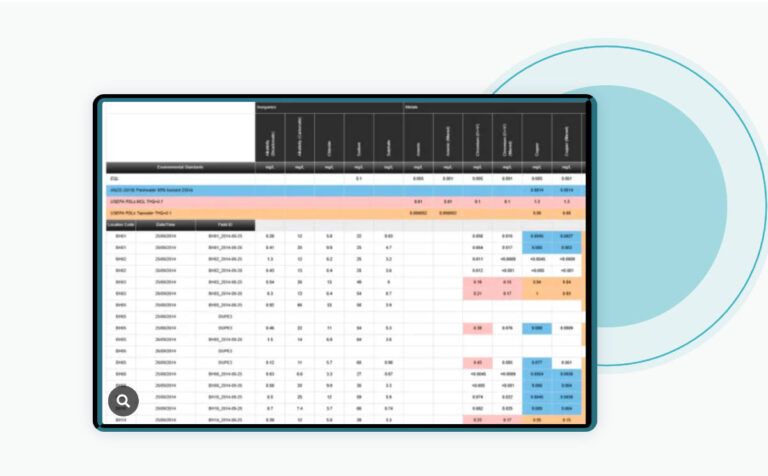
- Seamless Data Integration: Lab results are seamlessly integrated into ESdat, allowing automatic data reception for hassle-free visualization. Users can filter and view lab results directly on the geochemistry graphs. Additionally, manual data upload from Excel is supported, ensuring flexibility in data management.
- Freeware Apps for Everyone: ESdat Freeware Apps provide all users free access to ESdat GeoChem. The user-friendly interface and powerful visualization tools empower individuals and professionals alike to harness the benefits of geochemical data analysis.
- Enhanced Data Management for Subscribed Users: Subscribed ESdat users gain the advantage of centralized data management and analysis. This leads to improved data quality and significant time-saving benefits. Managing and analyzing data becomes more efficient, allowing users to focus on critical decision-making.
- Feature-Rich Enhancements in Version 4.5: The release of GeoChem is part of the ESdat Version 4.5 update. This release includes a host of features such as support for various geochemical graphs (Piper, Durov, Schoeller), GWSDAT Export for Mann-Kendall Trend Analysis, enhanced data frequency reduction via Logger Data imports, and the ability to export EDIFs for specific Monitoring Zones, Sites, or Projects.
“We’re thrilled to introduce ESdat GeoChem as part of our Version 4.5 release,” said Warwick Wood, Managing Director of EScIS. “Geochemical data plays a pivotal role in environmental projects, and our software empowers users with advanced visualization tools and streamlined data management, fostering more informed decision-making and optimized workflows.”
ESdat GeoChem is available now as part of ESdat environmental data management software Version 4.5. For more information and to explore the capabilities of ESdat GeoChem, please visit the ESdat Website or GeoChem directly.
About EScIS:
EScIS (Earth Science Information Systems) is a leading innovator in environmental and hydrogeological data solutions, dedicated to providing cutting-edge solutions for efficient data management and analysis. With a focus on empowering users with advanced tools, we strive to revolutionize how environmental data is visualized and utilized for informed decision-making. Our commitment to excellence drives us to deliver solutions that enhance productivity and effectiveness across various industries.
Related Articles on Geochemical Data Visualization and Analysis
Differences in Durov Diagrams and Stiff Diagrams
What are Schoeller diagrams in geo-chemistry
How to do Piper Diagrams in Chemistry Water Analysis
Exciting Software Update Unveiled for ESdat Users Worldwide, Elevating Data Management Experience


[…] Introducing ESdat GeoChem: Revolutionizing Geochemical Data Visualization and Analysis […]
[…] Introducing ESdat GeoChem: Revolutionizing Geochemical Data Visualization and Analysis […]
[…] Introducing ESdat GeoChem: Revolutionizing Geochemical Data Visualization and Analysis […]