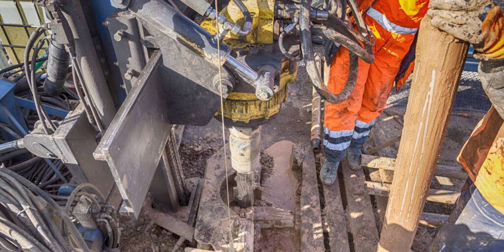
Geologic characteristics encountered while drilling a borehole are recorded in a borehole log
The geologic characteristics encountered while drilling a borehole are recorded in a bore log. To read a bore log, you will need to understand the types of data included in the log, such as depth, lithology, and geophysical measurements. The steps to reading a bore log are as follows:
- Learn the bore log format and the many types of data it contains.
- Find the depth scale, typically on the log’s left side. This scale will show the borehole’s depth at various points.
- Look for the lithology column, which describes the kind of rock or soil found at each depth interval. The varied rock kinds or soil colours may be represented in this column by descriptions, symbols, or colours.
- Look for geophysical measures that reveal details about the conditions beneath the surface, such as resistivity or natural gamma radiation.
- Use the information in the bore log to build a general understanding of the subsurface geology, including the types of rock or soil present, the depth of the different layers, and any subsurface features or anomalies encountered during drilling.
Be familiar with the bore log’s context and purpose, and consult with a geologist or other expert if you have any questions.
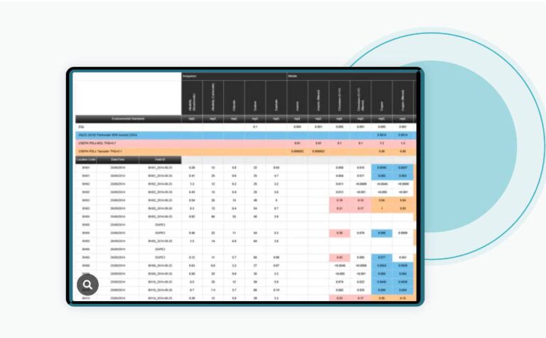
Bore Logging Data Collection with Data management Software
Configuring Bore Log exports to ESlog
What is Lithology?
Lithology describes rocks’ texture, mineralogy, and composition and their physical properties. It is a crucial component that geologists use to define and categorize rocks.
The physical characteristics of a rock that are used to determine its lithology include its colour, grain size, and texture. For example, a dark-coloured rock with large grains and coarse texture is likely to be basalt, while a light, small-grained, and finely textured rock could be a shale.
The mineralogy of a rock, or its types and relative proportions of minerals, is also used to determine its lithology. For example, a rock composed of the mineral quartz is likely to be granite, while a rock consisting mainly of the mineral calcite is likely to be limestone.
Finally, the structure of a rock, including its layering, bedding, and any visible features like fossils or fractures, can also be used to determine its lithology. For example, a rock composed of sandstone and shale layers is likely to be a sandstone-shale sequence.
Lithology is used to classify rocks and understand their origin, composition, and history. It is essential for interpreting subsurface conditions, especially in the oil and gas industry.
What are Geophysical Measurements?
Geophysical measurements are measurements of the physical properties of the Earth’s subsurface that help us understand the structure and composition of the subsurface. Typically geophysical measurements include the following:
- Seismic: This method uses sound waves to create images of the subsurface. In the oil and gas sector, it is frequently used to map subsurface rock structures and find potential hydrocarbon reservoirs.
- Gravity: This method measures the Earth’s gravitational field to infer the density of subsurface rock formations. It can be used to map subsurface structures and locate potential mineral deposits.
- Magnetic: The kind and distribution of underlying rock formations can be inferred using the magnetic method, which monitors the Earth’s magnetic field. It can identify possible mineral deposits and map subsurface features.
- Electrical: Using this technique, the electrical conductivity of underground rock formations is measured. It can locate possible mineral deposits, map subsurface structures, and identify subsurface fluids like water or hydrocarbons.
- Electromagnetic: This technique assesses the electromagnetic characteristics of underground subsurface rock formations. It can locate possible mineral deposits, map subsurface structures, and identify subsurface fluids like water or hydrocarbons.
- Radiometric: This technique measures the natural and artificial radioactive isotopes in subsurface rock formations. It can map subsurface structures, locate potential mineral deposits, and detect subsurface fluids such as water or hydrocarbons.
These measurements offer insightful data about the subsurface and are frequently combined to create a comprehensive picture of the geology and resources available.
What are Resistivity and Natural Gamma Radiation?
Resistivity and natural gamma radiation are two geophysical measurements used to study the subsurface.
- Resistivity: Using this measurement, you may discover subsurface rock formations’ electrical resistivity. A rock formation’s electrical resistivity is a measure of how well it can resist the flow of an electrical current. Resistivity measurements can be used to identify between different types of rock formations, including clay-rich shales and sandstone. They can also be used to locate subsurface fluids, such as water or hydrocarbons.
- Natural Gamma Radiation is a measurement used to find naturally occurring radioactive isotopes in underground subsurface rock formations. The elements uranium, thorium, and potassium all have isotopes that generate gamma radiation. These isotopes are found in small quantities in a wide variety of rocks and soil types, and their presence can be utilized to determine the kinds of rock formations that exist underground. Measurements of natural gamma radiation can be used to map underlying formations and identify possible mineral reserves.
Non-destructive techniques that can reveal crucial underlying information include resistivity and natural gamma radiation. To create a complete picture of the subsurface conditions, they are frequently integrated with other geophysical measures, including seismic, gravitational, magnetic, electrical, and electromagnetic.
What is Subsurface Geology?
Subsurface geology studies the geologic features and processes that occur beneath the Earth’s surface. This includes the composition, structure, and history of the rock formations, soils, and other materials that make up the subsurface and the processes that have shaped and continue to shape them.
To explore and extract natural resources, analyze natural disasters like earthquakes and volcanic eruptions, and comprehend the Earth’s history and evolution, subsurface geology is crucial.
Geologists use various methods to explore subsurface geology, such as drilling, mapping, geophysical measurements, and laboratory examination of rock and soil samples. They also use data from remote sensing techniques like satellite photos and aerial photography to examine the surface features that can reveal information about the subsurface conditions.
Subsurface geology uses many scientific disciplines, including geology, geophysics, geochemistry, and hydrology. It is essential to mining, oil and gas, civil engineering, groundwater resource management, and other industries.
What is Bore Log Software?
Borehole log software creates, edits, and analyses borehole logs. During the drilling process, geologic features are recorded in a borehole log, which typically includes information about depth, lithology, and geophysical measurements.
Users of borehole log software can enter, arrange, and analyze data from drilling, sampling, and testing conducted in boreholes. Logs, cross-sections, and other visual representations of borehole data can be made and modified using it. Additionally, it offers data analysis tools like statistical analysis, data visualization, and modelling capacities.
Some of the features that borehole log software may include:
- Data import and export capabilities
- Data validation and quality control
- Tools for data visualization, such as graphs, maps, and cross-sections
- Tools for data analysis, such as statistical analysis and modelling
- Reporting and documentation capabilities
Geologists, engineers, and other experts in the oil and gas sector, mining, civil engineering, and groundwater resource management employ borehole log software. It can be utilized to produce thorough subsurface models and offer valuable data for the planning and execution of subsurface projects.