There are many different types of data that can be used in environmental data management. These include numerical data, text data, images, and more. Each type of data has its benefits and drawbacks. Numerical data is easy to analyze and compare but can be difficult to interpret. Text data is easy to interpret but can be difficult to compare and analyze. Images can be helpful in visualizing data, but they can be difficult to store and manage.
ESdat is a specialist environmental database system; used to validate and import a broad spectrum of Environmental Data and to help users analyze and report it. ESdat can manage many types of environmental data, including the following:
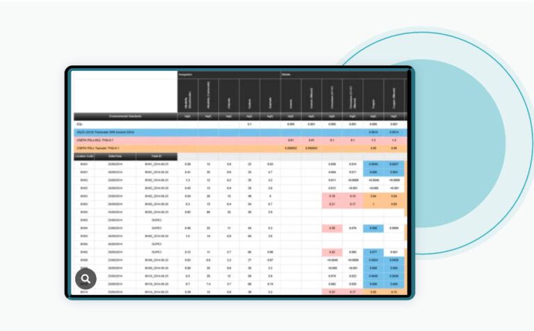
Laboratory Results
- Automated import of laboratory data
- Store certified PDF copies of a lab report
- Import all QA data (blanks, duplicates, holding times etc..)
Most laboratories can provide data in ESdat format, just ask your laboratory or see the list of compliant laboratories.
Importing laboratory data directly into ESdat removes transcription time and typographic errors and increases the ability to effectively check the data using the validation and QA tools that ESdat provides.
The “LabSync” service means laboratory reports are automatically uploaded from the lab, validated, and imported into ESdat, or flagged for review and re-issue by the lab. Once validated and imported, users receive an email with a link to review the laboratory report directly in the browser.
Field Data
- Surface water, groundwater, vapour and other parameters
- Water Levels
- Tablet data collection and offline forms
- Photos, documents and metadata
- Field options include: ESdat Field Portal, PLog, Excel forms
Environmental Standards
- Regulatory guidelines are preloaded and maintained
- Site or location-specific guidelines can be uploaded
- pH / Hardness / depth & matrix specific guidelines
ESdat comes pre-loaded with most regulatory guidelines. See the list of compiled environmental standards. Users can also add their own site-specific or other guidelines as required.
Environmental Standards and exceedances can be shown and flagged on all the ESdat outputs, including Chemistry Output Tables, Graphs, and Maps.
Scheduling and Sample Planning
- Sample Planning module integrated with field tablets
- Plan recurring sampling rounds
- Specify Locations, QA Samples, Analyses and Containers
- Assign to specific staff
- Pre-populate a eCOC & print if needed
- Electronic Chain of Custody to send requests to laboratories
Logger Data
- Rain, Wind, Temperature, Noise
- HiVol and Depositional Dust Sampling Parameters and Corrections
- Surface Water Flow, Groundwater Levels
- Air Quality
- Automated upload of logger files
- Support a variety of formats
- View on time-series graphs
See Logger Data
Geological, hydrogeological and borehole
- Borehole and well construction details
- Hydrogeological, geological and borehole data management
- Lithological, Geotechnical and Stratigraphic data
- Groundwater Data (levels, aquifers, aquifer tests)
- Pumping
- Groundwater depth to elevation conversion
- LNAPL depth to elevation density corrections
- Time-variant Top of Casing due to subsidence or excavation
Customisable
- Client-specific customizations available, or
- Extend the database schema in house
ESdat Server can also be customized to accommodate any specialist data not accommodated in the standard system. For example, it has been customized to manage lease and landholder contact tracking amongst others.
For more information on Integrated data management solutions