Whether studying the effects of pollution, assessing ecosystem health, or monitoring climate change, you’ll frequently rely on environmental field data to draw your conclusions. But what exactly is environmental field data, and why is it so important?
Understanding Environmental Field Data
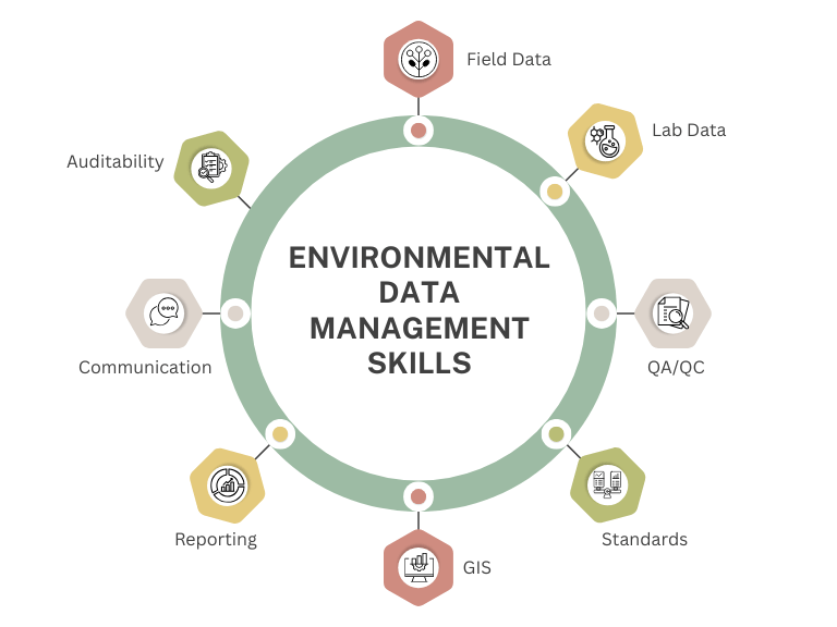
Environmental field data refers to information collected directly from natural settings like forests, rivers, lakes, urban areas, and even the atmosphere. This data can encompass various variables, including temperature, humidity, soil composition, water quality, species counts, and pollutant levels. The key characteristic of field data is that it is gathered on-site, often through direct observation, measurement, and sampling.
Why Collect Field Data?
Field data is essential for understanding environmental processes, assessing ecosystems’ health, and developing conservation and management strategies. By collecting data in the field, scientists can:
1. Monitor Environmental Changes: Long-term field data allows scientists to track environmental changes over time, such as the impacts of climate change, deforestation, or urbanization.
2. Assess Ecosystem Health: Field data provides a snapshot of an ecosystem’s current state, which is crucial for determining its health and identifying areas that may need conservation efforts.
3. Inform Policy and Management: Accurate field data supports evidence-based environmental management and policy decision-making. It helps policymakers understand the environmental impacts of proposed projects and activities, guiding regulations and conservation measures.
Types of Environmental Field Data
Field data in environmental science can be categorized into several types, each serving different purposes:
1. Physical Data: This includes measurements of physical attributes such as temperature, humidity, wind speed, and soil texture. Physical data helps in understanding the abiotic factors that influence ecosystems.
2. Chemical Data: Data on chemical composition, such as pH levels, nutrient concentrations, and pollutants, is crucial for assessing water and soil quality.
3. Biological Data: This involves data on living organisms, including species counts, population dynamics, and biodiversity. Biological data is vital for studying ecosystem health and the effects of environmental changes on flora and fauna.
4. Geospatial Data: Geospatial data is collected using GPS, remote sensing, and GIS (Geographic Information Systems) to map and analyze the spatial distribution of environmental features and phenomena.
Tools and Techniques for Collecting Data
Collecting environmental field data requires a variety of tools and techniques, depending on the type of data being gathered:
• Sampling Equipment: Tools like soil augers, water samplers, and nets collect physical environmental samples.
• Sensors and Instruments: Devices like thermometers, hygrometers, and pH meters provide real-time measurements of environmental variables.
• GPS and GIS Tools: These tools are used for mapping and spatial analysis, helping scientists understand the geographic distribution of environmental data.
• Field Notes and Observations: Detailed notes and observations made by scientists in the field are crucial for contextualizing data and noting any unusual conditions or occurrences.
The Challenges of Data Collection
While collecting data is essential, it has its challenges. Fieldwork often involves:
- Working in remote locations.
- Dealing with harsh weather conditions.
- Ensuring data accuracy in variable and unpredictable environments.
Additionally, logistical issues like transporting equipment and obtaining necessary permits can complicate field studies.
Another challenge is the variability in the data itself. Environmental conditions can change rapidly, meaning field data collected one day might differ significantly from data collected the next. This variability must be accounted for in data analysis and interpretation.
The Role of Technology in Data Collection
Technology advances have revolutionized data collection and analysis. Drones, satellite imagery, and automated sensors allow the collection of large volumes of data over extensive areas with minimal human intervention.
Environmental data management software like ESdat provides a comprehensive platform for managing all stages of large or recurring field programs. With robust management and approval tools built in, you can easily plan, execute, and report entire field programs electronically.
This technology enhances the accuracy and efficiency of field data collection, providing scientists with more comprehensive and detailed datasets.
Conclusion
Environmental field data is the foundation of much of the work done in environmental science. It provides the raw information needed to understand natural processes, assess environmental impacts, and guide conservation efforts. Learning to collect, analyze, and interpret field data is essential to undergraduate education, preparing them for environmental science, research, and management careers.
Related Articles to Environmental Data
Enhancing Environmental Data Collection with ESdat Field Programs
How to improve your environmental data confidence
Environmental Compliance with Data Management Software
Field and Sample Planning Optimized with LSPECS: The Ultimate Add-On to ESdat